

Xploreit Map of County Kerry, Ireland
Published on 7. July 2007
Other
Sheet map, folded
978-0-9552655-1-8 (ISBN)
Description
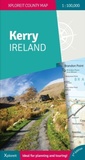
With spectacular coastal and mountain scenery, County Kerry - "The Kingdom" - is one of the most enchanting counties of Ireland.This map is an invaluable tool to use to discover its magical treasures, hidden beauty spots and world famous attractions."The Xploreit Map of County Kerry" includes the entire 'Kingdom' of Kerry along with parts of counties Clare, Limerick and a large part of County Cork. Famous tourist destinations such as Killarney National Park, the Dingle Peninsula, the Skellig Islands (a UNESCO listed World Heritage Site), Derrynane House and the 'Ring of Kerry' scenic route are all shown on one double-sided map sheet. It illustrates a magical landscape of mountains, lakes, woodlands, rivers and streams bordered by a rugged Atlantic coastline which is the longest of any county in Ireland.Golf courses, angling locations, beaches for swimming and surfing, historic sites, tourist centres and a host of other points of interest are clearly identified making this map an invaluable tool for both visitors and locals alike. Several scenic drives, cycle routes and way marked walks are shown.The scale of the Kerry map is 1:100,000.
More details
Series
Language
English
Place of publication
Ennis
Ireland
Publishing group
Fountain Software and Publications Ltd
Illustrations
2 illustrations
Map scale
1:100000
Dimensions
Height: 250 mm
Width: 105 mm
ISBN-13
978-0-9552655-1-8 (9780955265518)
Copyright in bibliographic data and cover images is held by Nielsen Book Services Limited or by the publishers or by their respective licensors: all rights reserved.
Schweitzer Classification
Other editions
New editions
Other
06/2024
3rd Edition
Xploreit Maps
€21.50
Shipment within 3-4 weeks