

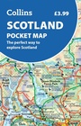
Scotland Pocket Map
The Perfect Way to Explore Scotland
Published on 3. March 2022
Other
Sheet map, folded
2 pages
978-0-00-849257-1 (ISBN)
Description
Handy little full colour map of Scotland. Excellent value and very detailed for its size. Double-sided folded map with the Central Belt, southern Scotland and northern England on one side and northern Scotland including Orkney and Shetland on the reverse.
This map features:
* Clear mapping at a scale of 8.7 miles to 1 inch
* National Tourist Routes showing best routes through the most scenic areas
* Top 100 places of interest
* Park and Ride locations
* Ideal companion to a sat-nav - it enables route planning and route sense-checking
Essential for those planning a trip or who want an inexpensive and easy-to-use back up for a sat-nav.
More details
Language
English
Place of publication
London
United Kingdom
Publishing group
HarperCollins Publishers
Illustrations
Index
Map scale
1:550000
Dimensions
Height: 140 mm
Width: 90 mm
Thickness: 7 mm
Weight
50 gr
ISBN-13
978-0-00-849257-1 (9780008492571)
Copyright in bibliographic data and cover images is held by Nielsen Book Services Limited or by the publishers or by their respective licensors: all rights reserved.
Schweitzer Classification
Other editions
New editions
Other
approx. 04/2026
Collins
€5.50
Not yet published
Previous edition
Other
02/2018
Collins
€24.94
Article exhausted; check for reprint
Person
Explore the world through accurate and up-to-date mapping.